Hazards
Stay risk informed. Be prepared.Switzerland’s multi-hazard early warning system
Gathering accurate and reliable data for weather forecasts is the first link in the chain. But reliable data is only truly effective if it is shared. Switzerland's early warning system is effective because all parties – from the local to the institutional, from the municipal to the federal level – share the data they collect within the early warning network.
They also share a common understanding: working together to protect the public.
Important, often life-saving, decisions are taken based on the data.
People
Heat wave
Manager of a nursing home
Wind
Manager of a construction site
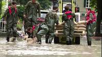
Floods
Head of local fire brigade
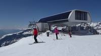
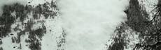
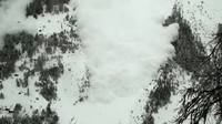
Avalanche
Manager mountain railway
Earthquake
Head of local municipality
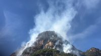
Forest fire
Head of crisis management unit
Storm
School teacher
Data
Data sources

Warnings
Warnings
Today, the responsible federal agencies issue warnings for different types of natural hazards. These agencies are members of the Steering Committee Intervention in Natural Hazards, known by its German acronym LAINAT. The National Emergency Operations Centre within the Federal Office for Civil Protection disseminates warnings and forecasts from the various agencies to the affected cantons and other partners in the situation network.
Municipalities advise the population on what to do – or not to do – in case of a natural hazard. For example, vacating areas threatened by floods or abstaining from lighting fires outdoors during extreme dryness. Individuals also take important decisions to prevent loss of life and damage to property: from shutting down a mountain railway to taking a school class to a museum instead of on a hike.
Channels
Channels
Partnership
A strong partnership forges the early warning chain
The Swiss government learned an important lesson: a successful early warning system depends on all actors working together and sharing information.
LAINAT promotes preparation for extraordinary natural events, coordinates the different mandates of the offices involved and manages projects on hazard preparation, warning and alerting. Through the close collaboration of six federal offices and institutes, LAINAT ensures that all actors involved in data collection, forecasting and early warning measures speak as one voice. To this purpose they also agreed on a common warning system with unified warning areas and warning levels. In case of a major event leading to natural hazards, they publish one bulletin and gather the relevant information on common platforms.
Partners

Swiss Federal Office for Civil Protection (FOCP)
The FOCP is responsible for civil protection at the federal level. It supports agencies that are active in mitigating risks and in managing incidents in the federal authorities involved, the cantons and the partner organisations of the civil protection system.
Federal Office for Meteorology and Climatology (MeteoSwiss)
Switzerland's national weather and climate service, operates the
national surface and radar measurement network, collects, manages and analyses
weather and climate data. It produces forecasts, informs, warns and advises.
Federal Office of the Environment (FOEN)
The FOEN ensures the sustainable use of natural resources, including soil, water, air and forests. It is responsible for minimising natural hazards, including floods and forest fires, reducing risks to the environment and human health from excessive pollution, and conserving biodiversity.
Swiss Seismological Service (SED)
The SED is responsible for monitoring earthquakes in Switzerland and its neighbouring countries and for assessing Switzerland's seismic hazard. When an earthquake happens, the SED informs the public, authorities, and the media about the earthquake's location, magnitude, and possible consequences.
Institute for Snow and Avalanche Research (SLF)
The SLF is an internationally renowned research institute. In addition to basic research, it conducts applied research and offers various services, including the national avalanche bulletin. The institute researches snow, atmosphere, natural hazards, permafrost and mountain ecosystems, and develops innovative products.
Federal Office of Topography (swisstopo)
Swisstopo, Switzerland’s geoinformation centre, is responsible for collecting, managing and publishing official spatial geodata. The Competence Center Rapid Mapping at swisstopo supports the collection and provision of geodata for the documentation of natural events. Pre- and post-disaster data are offered as a basis and for comparison purposes.
Abroad
International cooperation
Altersheim
Heat wave
Farmer
Bildmaterial: wahrscheinlich Archiv oder Spantandreh bei Frostprognosen
Wind
Earthquake
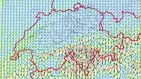
Radar
Five radar stations
Hydrological measurements
260 gauging stations on surface waters
Head of local fire brigade
Forest fire
Weather satellites
MeteoSwiss obtains satellite data from EUMETSAT, a consortium of European countries which together operate METEOSAT, and from other Earth observation satellites.
Automatic measurements and observation of snow cover
Switzerland's dense avalanche warning network, its high level of training and expertise and its management of avalanche risks were recognised as a global cultural treasure and given UNESCO intangible cultural heritage status in 2018.
170 automatic measuring stations
Manager mountain railway
Thunderstorms
Weather stations
Radio sounding is one of the pillars of meteorological services. Twice a day, MeteoSwiss carries out radio sounding using sounding balloons for the purpose of measuring key meteorological parameters in the atmosphere at high elevations.
Switzerland's only aerological sounding station is located at the Payerne regional centre of MeteoSwiss. Two soundings are performed here every day at midnight and 12 noon.
160 automatic monitoring stations
Forest fire danger observations and information
Supercomputer-based forecasts
Earthquake network
150 seismic monitoring stations
MeteoSwiss app
The reliability of the data and the app's easy-to-use features contribute to its popularity.
The measurements track weather developments in real time. One of the most-used features shows past and future precipitation distribution. Different types of weather forecasts, which cover up to eight days and are updated several times a day, allow users to plan their activities. They can also subscribe to push notifications for every locality in the country. The app displays all natural-hazard warnings. According to a representative population survey, more than 70% of the respondents use the app regularly,
www.meteoswiss.ch
Natural Hazards Portal
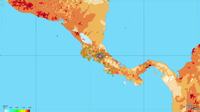
Climate Services in the Andes – CLIMANDES
Link to PDF
Alertswiss app

This app provides up-to-date information that can protect and save lives. Users receive cantonal alerts, warnings and information about their current location directly on their smartphone. It also allows them to prepare a personal emergency plan.
To broaden the dissemination of this app, it will be linked to the MeteoSwiss app in 2019.
Glacier lake outburst flows in the Yarkant river
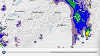
GIN
Overview of the GIN Platform
Earthquake early warning in Central America – EWARNICA
The damaging seismic waves that an earthquake emits are preceded by P waves that travel faster but with smaller amplitude. Real-time detection and interpretation of P waves allow for an estimation of the impact of the earthquake, which is used to send a warning before the damaging waves reach the population. Effective earthquake early warning (EEW) is only possible with a dense network of real-time and reliable strong motion seismometers.
(Video animation by SRF Einstein)
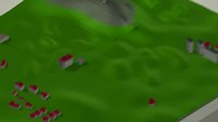
City Resilience Program in Vietnam
In order to move from a flood-response approach to a proactive, coherent and multi-sectoral approach, an integrated flood-risk management and an early warning system are being developed in order to support economic investment, early warning dissemination, as well as disaster preparedness and response.


 Stay risk informed. Be prepared.

 People